

While aiming to better enable housing capacity, Proposed Plan Change 120 (PC120) also places greater emphasis on ensuring development occurs in locations in Auckland where natural hazard risk can be appropriately managed.
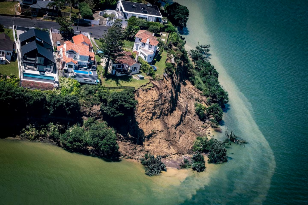
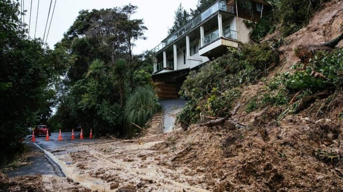
These changes were spurred on from Auckland’s extreme weather event in 2023 which resulted in widespread flooding, landslips and coastal erosion and inundation throughout the region. Ongoing weather events and climate change effects have highlighted to Auckland Council the need for better management of natural hazards. This increased management of natural hazards is part of the Council’s Proposed Plan Change 120 (PC120) to the Auckland Unitary Plan. This introduces new rules and standards related to natural hazards and contains new resource consent triggers.
Immediate legal effect
A key point to be aware of is that PC120’s natural hazard provisions have immediate legal effect from 3 November 2025.
This means:
- the updated Natural Hazards provisions are already in use, already trigger the need for resource consent in some cases, apply to current resource consent applications, and already influence Council’s decision-making;
- current consent applications are assessed under this framework;
- additional information (including geotechnical and flooding assessment) may already be expected.
Even though PC120 is still going through the plan change process, including submissions and hearings, it is already influencing land development in Auckland now.
PC120 Landslide Provisions
PC120 updates the Natural Hazards provisions of the Auckland Unitary Plan and provides a more structured approach to managing land instability through new rules, standards, and assessment criteria. It also introduces a Landslide Hazard Risk Assessment Methodology (Appendix 24 of the AUP-OP) for assessing landslide risk.
In practical terms, if your property is on or near a slope (including within 150m of where debris may reach your site), this may affect:
- whether you need resource consent for your development (which can include earthworks, additions and alterations),
- what technical information you need to provide,
- how feasible your project is, and if it should be redesigned.
This can apply not just to new buildings or new dwellings, but also other works including renovations, earthworks, vegetation removal and subdivision.
A shift to a risk-based approach
Under PC120, the focus has shifted from simply identifying natural hazards, to better assessing and managing natural hazard risk.
This involves assessing:
- how likely a hazard is to occur,
- what the likely consequences could be,
- how vulnerable the activity is (for example, a house vs a driveway vs an office).
From this, the hazards are generally categorised as:
- Acceptable risk – development is anticipated.
- Tolerable risk – development may be possible with mitigation.
- Significant risk – development is generally discouraged.
Implications
In very general terms, resource consent applications are expected to:
- demonstrate they will not increase risk to people, neighbouring properties, or infrastructure,
- consider how the development interacts with slope stability,
- be supported by appropriate technical input where required.
Activities that commonly trigger assessment include:
- earthworks (cutting, filling, excavation),
- vegetation removal on steeper or unstable slopes,
- changes to drainage or stormwater,
- building or alterations on or near slopes,
- subdivision and accessways on or near steeper or unstable slopes.
Even relatively small projects can sometimes fall within this scope.
Updated mapping
PC120 is supported by new region-wide landslide susceptibility mapping, informed by the findings of the [Auckland Regional Landslide Susceptibility Assessment (Technical Report TR2025/7) May 2025 by Auckland Council. You can see that report here.
This mapping:
- identifies areas where landslides are more likely,
- informs planning overlays and Land Information Memorandum (LIM) information,
- captures more properties than previous datasets.
You can find more information on the new landslide susceptibility mapping here. [link to Landslide mapping blog]
It is important to note that this mapping is high-level. It highlights potential risk areas, but it does not confirm whether a specific site or building platform is suitable for development.
Need for site-specific assessment
Because the landslide susceptibility mapping is regional in scale, decisions are still heavily based on site-specific assessments. These are assessments you will need to provide as part of your resource consent application (or to demonstrate that a resource consent is not required).
These assessments help to:
- confirm the actual level of risk on a site,
- understand how a proposal affects that risk,
- determine whether mitigation can achieve an acceptable outcome.
Depending on the site and the level of natural hazard risk, mitigation might involve:
- locating buildings, access and services away from higher-risk areas,
- managing drainage and runoff,
- limiting or modifying earthworks,
- appropriate structural or foundation design.
Practical takeaways
We recommend that as part of your preliminary investigations you:
- Engage a good planner
A planner can help identify potential risks, other specialists’ inputs needed upfront and ensure all the necessary information is obtained early to inform your development design.
- Check early
Understand whether your site may be affected by landslide susceptibility mapping. Your planner can assist in identifying the specialist inputs then required, and the scope of that work.
- Expect more technical input
Specialist advice is more commonly required under PC120. You will not be able to address resource consents under PC120 on your own.
- Design with the site in mind
Layout, drainage, and earthworks decisions are increasingly important when natural hazards are present.
- Avoidance is sometimes the simplest solution
In higher-risk areas, avoiding development in that location may be more practical than mitigating it.
Who to engage
Depending on your project, you may need input from:
- Planning consultants – to coordinate the application and navigate the Auckland Unitary Plan and RMA framework. Your planner will help identify the inputs required, the scope of those inputs, the relevant rules and standards and bring this together to influence the development design.
- Geotechnical engineers – to assess slope stability and provide design recommendations.
- Civil engineers – for stormwater and drainage design.
- Arborists – where vegetation removal is proposed or stability relies on existing vegetation.
Early engagement and coordination between these specialists can help avoid delays and reduce costs later in the process.
Your site could also be affected by flood hazard risks. You can find out more about this on our blog here and the maps related to that here.
Final thoughts
Landslide risks are an important consideration when buying or developing land in Auckland. Proposed Plan Change 120 places greater emphasis on managing natural hazard risks and improving resilience but is still subject to change through the plan change process.
If you are considering development on a site affected by natural hazards, early planning input can help identify potential constraints and develop practical solutions.
If you’re looking at developing a site, get in touch with us at Planning Plus. With over 65 years of experience, we will assist you with the process, along with the management of your resource consent application. You can contact us on hello@planningplus.co.nz or (09) 427 9966.

Achini is an Intermediate Planner at Planning Plus®. and has 5 years of experience in resource consenting. She has processed a variety of consents including residential, commercial, subdivision, air discharge, and soil contamination consents.
Achini holds a hold a Bachelor’s of Urban Planning (Honours) from the University of Auckland and is an Intermediate Member of the New Zealand Planning Institute. Achini previously served as the Emerging Planners representative for the Top of the South region.
