

Understanding whether your property is affected by flooding is often the first step in any development project. In Auckland, the easiest way to check this is by using Auckland Council GeoMaps — a free online mapping tool provided by Auckland Council.
This guide walks you through the basics. Please remember though the maps are based on high level modelling- you may need to also engage a specialist to assess your specific site and development.
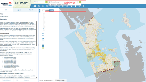
Step 1: Open GeoMaps
Go to the GeoMaps website here.
Once loaded, you’ll see a map of the Auckland region with a search bar in the top left.
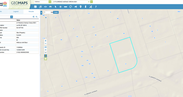
Step 2: Search for your property
Enter your address into the search bar and select the correct result.
The map will zoom directly to your property.
Tip: Make sure the blue boundary outline matches your site — this confirms you’re looking at the right property.
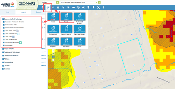
Step 3: Turn on flood hazard layers
Select the second icon below the address bar, then click on “Assets.”
In the left-hand panel, select “Catchment and Hydrology,” and tick the layers you require. For flood hazards, this includes:
- Flood plains,
- Flood prone areas,
- Overland flow paths,
- Flood Hazard Areas (these relate to PC120 flood hazards).
Tip: Flood plains and Flood Hazard Areas overlap. If both are selected, the flood plains layer will obscure the Flood Hazard Areas.
Step 4: What this means for your project
If your property is affected by flood hazards, it does not necessarily mean development cannot proceed — but it may mean:
- Resource consent is required,
- Additional reports (e.g. flood assessments) are needed,
- Design may be required to manage risk.
You can read more about common resource consent triggers in our related blog on flood hazards here.
Interested in landslides?
If you think your site may be at risk of landslides, you can find out more in our blogs here and here.
Need help?
GeoMaps is a great starting point, but it is only a screening tool. If you’re unsure how flood hazards affect your property or development plans, it’s best to seek advice early. A planner can help interpret the mapping and identify the next steps.
Please don’t hesitate to get in touch with us at Planning Plus to discuss your development project and resource consent process. We can assist with interpreting flood hazard constraints, coordinating specialist input, and guiding you through the resource consent process.
You can contact us on hello@planningplus.co.nz or (09) 427 9966.

Shayne is an Intermediate Planner at Planning Plus and has five years resource management experience focusing on commercial, residential, and subdivision projects across Auckland, in addition to experience in landscape architecture. She has worked extensively in the private sector, leading end-to-end resource consent processes and collaborating closely with clients, councils, designers, and technical specialists.
Shayne holds a Master of Urban Planning (Professional) and a Bachelor of Landscape Architecture and is an Intermediate Member of the New Zealand Planning Institute. In addition to English, Shayne is also fluent in Mandarin Chinese.
